COURSE
CRITICAL CARTOGRAPHY
University of Basel, Urban Studies, MA Critical Urbanisms, Fall 2023
Alaa Dia
MA Critical Urbanism-University of Basel
MA Critical Urbanisms - Instagram
QUOTING SPACE
SPACES FOR NON-CITIZENS
Prepared for one of the term assessments
SPECTRUM OF CITIZENSHIP
WHAT DOES A LACK OF DOCUMENTS MEAN, SPATIALLY?
Visualizing and mapping the lived experiences of people with different statuses can provide a deeper understanding of the spatial, social, and emotional aspects that shape urban fabric. This project, as an interactive map, simply puts us in relation to the people during the interviews and principally frames the similarities and differences between people based on their legal or illegal status in Switzerland. Our aim was then to render visible disparities between three certain individuals below through in-depth participatory mapping.
Person X, an undocumented male, 45, is from the Saharan region and was granted an N-permit in Switzerland; his permit was revoked, and he has been without legal documents (Sans-Papiers) for at least three years.
Person Y, with legal documents, female, 35, is a Swiss national citizen from the south of the country who has been studying and working in Basel for the past two years.
Person Z, with B permit documents (temporary stay), male, 28, is an international student from Eurasia who has been in Switzerland for the last seven months.
At the beginning, over Person X, we analyzed someone's specific image based on his illegal status to show spatial disparities, reveal utilization of urban areas, and depict unequal patterns of movement concerning limitations in accessing certain areas, differences in frequented locations, and entitlements of inclusion or exclusion based on legal status. Narratives, stories found in detail during the interview and connected to one person, need comparisons, just as participatory mapping requires more quantities to be more representative. In this sense, Person X, without legal documents, was our focal point, and then we should have been able to compare him with someone either with documents or temporal documents.
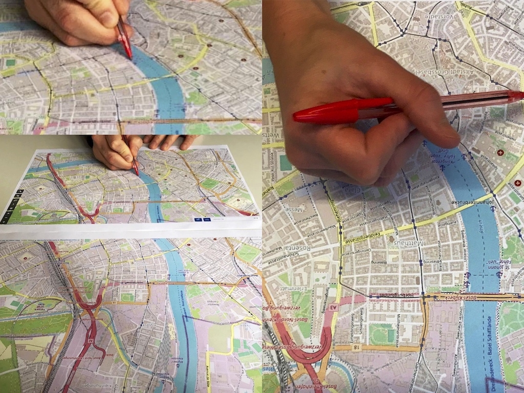
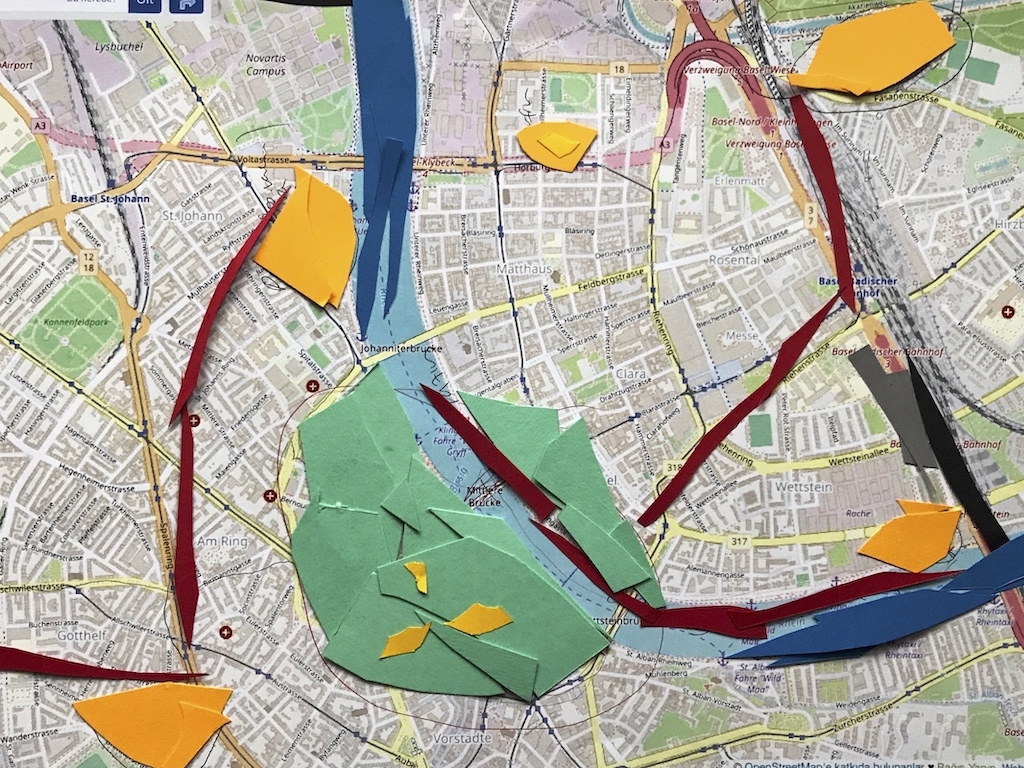
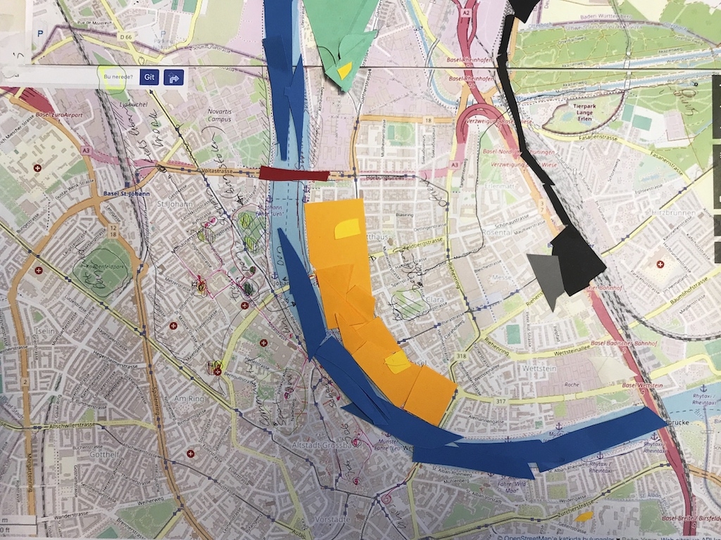
Participatory mapping
Following Person X, we decided to interview two more people, Persons Y and Z, to measure and compare his outcome concerning his daily spatial restrictions, personal limitations, and emotional challenges. The maps achieved highlight distinct spatial patterns among Persons X, Y, and Z and illustrate the freedom or constraints of movement faced by each person.
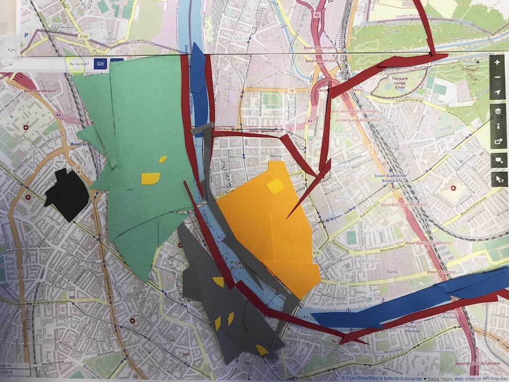
After analyzing those data with the information gathered from those interviews and conducting participatory mapping, we created three draft maps showing how these three people are navigating the city following real and relative facts. We analyzed their movements in the city simply through the lens of daily life activities based on social interactions, work, and education. These gave us a clear understanding of how having a different status creates different experiences of borders, freedom, and citizenship, so we could overlap their outcomes in the final work, which includes simplified drawings of 3 maps for Persons X, Y, and Z and 1 overlapping map for intersections and differences.
This project model aims to overlap different experiences of borders, freedom, and spatial stories and observe what legal, or illegal, status brings to those people who have totally distinct citizenship or non-citizenship positions. The participatory mapping process made these intersections even more visible over aspects of citizenship: for one, borders and restrictions are everywhere; for the other, freedom and mobility are unlimited; and for the third, freedom is conditional based on temporal elements. These maps show what the intersections between various areas in the city mean for all three people voicing their different experiences.
During the interviews with these 3 people, we had the chance to make a comparison about the fragmentation of home, social, work, education, and mobility patterns basically attached to Klein and Gross Basel. To measure the differences between the city experiences of these people, we first set up someone who has no permission, then someone who has unlimited permission, and someone in between who has time-limited permission based on the fact that at a certain time his student permit will run out; these define how they access the city, navigate, and experience it with freedom, unfreedom, and conditionally relative freedom. During the work, we used layers to consider for mapping purposes based on spatial restrictions, citizenship, privileges, safety and security, sense of belonging, sense of community, family and friends, recreational time, freedom of movement, sense of borders and borderless, finances and economics, labor, work, education, and rights and emotions to the city since everyday life can make a connection of all scales following their own realities. At the same time, tracing the spaces of navigation, avoidance, day and night time of movements, and places where they can or cannot go or are welcomed or not were sub-layers of this process.
On one hand, the maps explore how much living anonymously and unnoticed every day affects people's sense of belonging, and on the other hand, they explain what kinds of activities are present in their daily lives that strengthen these senses. Clara Wittich, in her master’s thesis, describes these people as those who never had residence status (visa-free entry, tourist visa expiration, unauthorized family reunification) and people who had residence status but lost it (Wittich, 2023:13). In this sense, the maps show varying degrees of entitlement and inclusion or exclusion in public spaces, which shapes the sense of belonging for the individuals; at the same time, they depict obstacles faced in accessing services, employment opportunities, engaging in community, making friends, and seeking support.
Antonsich explains that the term “belonging” is vaguely defined. He argues that belonging should be seen as a personal, intimate feeling of being “at home” in a place (place-belonging), as well as a discursive resource that constructs forms of socio-spatial inclusion and/or exclusion (politics of belonging), asserts, justifies, or resists. In this context, the maps present themselves as a form of belonging and explore the full context of the term “belonging” or “spaces of belonging." The maps also explore the question of to what extent people with undocumented status, Sans-Papiers, in Switzerland, who have no legal security and are often separated from their families, value their sense of belonging. At this point, the study revolves around transnational-regional relations, family, and the border and is particularly interested in how undocumented people live these experiences.
The entire process unveiled the complexities of legal or illegal status on spatial navigation patterns on an individual and public scale based on conversations about the movements, access, and privileges attached to these statuses in a comparative format. Analyzing these intersections highlighted how legal or illegal statuses influence everyday experiences, providing insights into entitlements shaped by movement across different legal statuses in Basel. People with different status gave us a clearer perspective on the spatial story of a person (Sans-Papiers individuals) with no right to the city and made us think about the friction articulated by people and their relation to places as the spectrum of citizenship for a non-citizen is reduced by the punitive nature of the law to the lowest level of spatial freedom; for us, this scanned the lives of Sans-Papiers individuals to investigate how much "freedom" they have in accessing the city.
In conclusion, we were exploring the impact of spatial restrictions on an individual without valid documents, comparing his daily experiences with those of two other individuals: one with full freedom as a Swiss citizen and the other with relatively freedom holding a temporary resident permit in Basel. This helped us understand the challenges encountered by individuals without valid documentation in accessing spaces, social integration, and a sense of belonging while navigating the city. We then visualized these experiences through participatory mapping; these maps are rich in data, as qualitative questions intended to encourage conversation were asked during the interviews to encapsulate the experiences of different people based on their lived experiences and investigate entitlement, movement, and overlapping intersections of diverse jural statuses in Basel’s urban life.
*Readings by Mark Salter (nuances of legal statuses and entitlements within urban spaces—differing legal statuses impact people's relations, movement, and sense of belonging to the cityscape) and Etienne Balibar (polysemic border, meaning different things for different people) during class inspired us to focus on what a border is and how people live in relation to it, which covers the theoretical subsidiary of the project.
Person X
Person Y
Person Z